

 I don’t need to tell you the world has been crazy as of late. Rather stormy even, you might say. Take the cue and make a day’s getaway to embrace the OG storm: The Pacific Ocean at full throttle.
January 11 through 13 is the last of this winter’s series of tides that reach the highest they will all year – called King Tides. Corvallisites, what follows are some top-notch storm watching spots along Oregon’s mightily magical Central Coast. But first, some trip considerations.

Before you head out, do check online for the forecasted wave height and tides. While on occasion the coast will see wave heights into the upper twenties of feet, even heights around half of that extreme can provide some excellent entertainment at the sites I suggest.
Keep in mind that while summer’s beaches are wide and open, winter’s are a much more watery world at even mid-tides. If you want to walk on the sand without the risk of sneaker waves and logs rolling about, aim your stroll for smack dab on the low tide. If you can’t make it out to the sand safely, don’t worry – you can actually see more of the ocean’s stormy glory from the higher elevation locations you’ll learn about here.
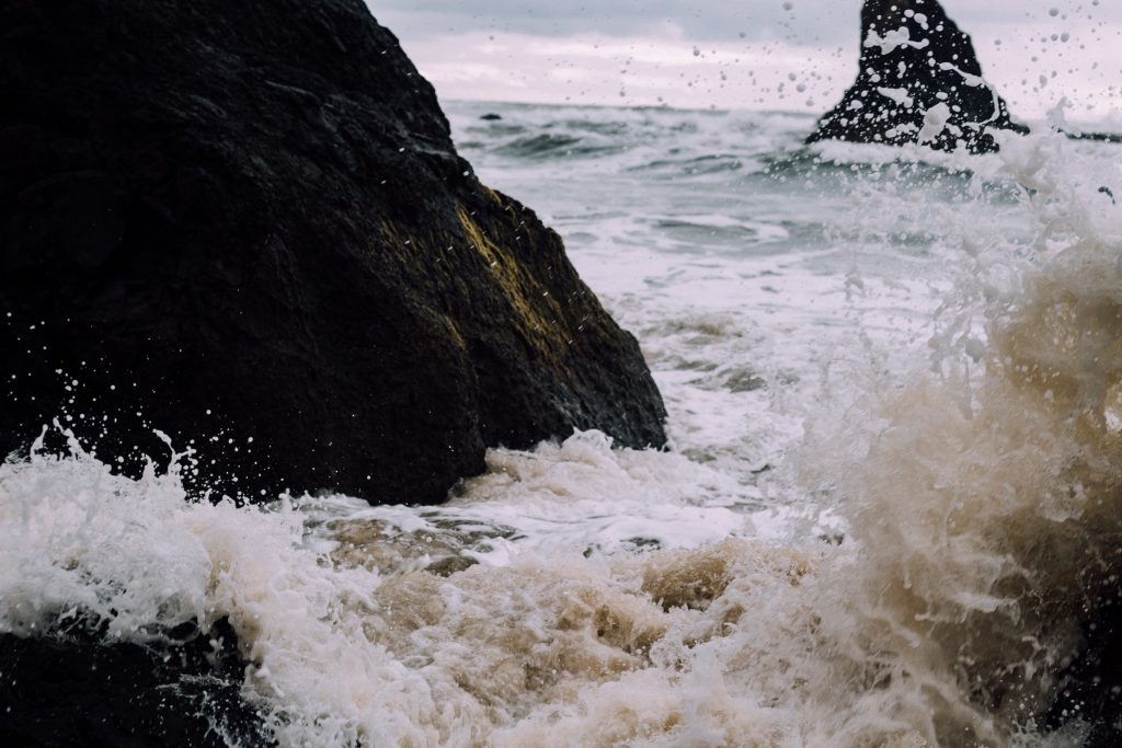
Don’t be enticed to walk past any barriers to try to get closer to the action on the rocks.
With the way the world’s going, this year entails more safety considerations than ordinary. Don’t crowd any other storm watchers – stay at least six feet away from anyone else even in this outdoor and relatively safe activity. Many stops have State Park bathrooms where extra etiquette is necessary: wear your mask when approaching and going inside them, do your business cleanly, wash your hands thoroughly, and don’t linger any longer than necessary. Coastal businesses would be happy to have your dollars, but not if you don’t keep everyone’s safety in mind inside them too. Again, wear your mask properly covering both mouth and nose when going in, respect capacity limits, sanitize at the door, take food to-go, and tip extra.
Depoe Bay Area
North of the Whale Watching Capital of the World and the World’s Smallest Harbor, you will find Boiler Bay State Scenic Viewpoint, a pullout on Government Point with parking and grassy areas galore. A wooden fence marks the park’s bounds and all along it are fine places to watch the ocean in all her rage.
In Depoe Bay proper, parking can be found all along the seawall. Sometimes these spots go fast, so drive slowly while you look for them, and you might just be showered by water hitting the rocks below you from the Spouting Horn.
South of Depoe Bay is another State Scenic Viewpoint called Rocky Creek. Similar to Boiler Bay, there are grassy areas to watch from, as well as a short trail on the north end to take you to what is called a whale watching platform. As it turns out, most whale watching spots also make great storm watching spots, but generally don’t provide both opportunities at the same time.
Otter Rock and Devil’s Punchbowl
When a place invokes the Devil’s name outright, you know it must be good for the task at hand. From Rocky Creek, you can take the scenic route to Otter Rock, stopping at Cape Foulweather on the way if you so choose. Perched many hundred feet above the ocean, there is a different scale to the sea that enhances the power to be felt.
Parking at Otter Rock ordinarily fills up quickly by surfers on calm days, and you may notice many orange cones marking off neighboring streets to the State Park. The summer wreaked some havoc on this place in terms of visitor numbers. If for some reason you can’t find a legit parking spot, do move on. But I suspect it should be no problem in the middle of the storm. The Devil may be reckoned with down at the end of the road by Mo’s.
Yaquina Head Outstanding Natural Area
Relatively frequent as it is that I visit Yaquina Head, I still can’t get over the outstanding nature of this place. Truly, the Bureau of Land Management aptly named this one. It costs $7 to drive in here, but $0 if you walk in. If you go the latter route, park in the lovely lot at Agate Beach Wayside, then walk down Lighthouse Road to the end. The 360 degrees from the deck below the lighthouse can’t be beat. On a clear day, you can see Cape Foulweather to the north, Cape Perpetua to the south, and a higher peak of the Coast Range called Table Mountain to the southeast. And of course, to the west, the Pacific’s long-journeying waves at last come to crash on various rocky islands jutting out from the headland. Outstanding!
Cape Perpetua Scenic Area
While all the other locations I’ve mentioned thus far have you venturing north on Highway 101 after you meet it from the 20, this one is for the southernly-inclined day tripper. You’ll pass Seal Rock, Waldport, and Yachats before you arrive, the foremost and latter of which also have some fine storm-watching stops you may want to consider adding in. Once you cross the Yachats River, Highway 101 gets really curvy and climby to get travelers around the cape. In this area, you may deal with the Devil again via Devils Churn Day Use Area. You many also want to drive or hike up to the top of Cape Perpetua for a more grand-scale view.
For more information on the public lands suggested, check out:
– Cape Perpetua: https://www.fs.usda.gov/recarea/siuslaw/recreation/recarea/?recid=42265
– Yaquina Head Outstanding Natural Area: https://www.blm.gov/learn/interpretive-centers/yaquina
– Oregon State Parks: https://stateparks.oregon.gov/index.cfm?do=visit.status
For 2020 Tide Tables: https://stateparks.oregon.gov/index.cfm?do=main.loadFile&load=_siteFiles%2Fpublications%2F%2F2020_Tide_Tables_Central_Coast012531.pdf
For Wave Forecasts: https://marine.weather.gov/MapClick.php?x=96&y=213&site=pqr&zmx=&zmy=&map_x=96&map_y=213#.X-0RIi1h1-U
And, more About King Tides: https://www.oregonkingtides.net
By Ari Blatt
Do you have a story for The Advocate? Email editor@corvallisadvocate.com